USA States and State Capitals Map - A3 (30cm x 42cm) Childrens Wall Chart Educational Kids Childs Poster Art Print WallChart
1,459 G

U.S. Map Poster (32 x 50 inches) - Laminated: - a QuickStudy Reference Poster – May 31, 2013
2,839 G
SMALL - 100 NORTH AMERICA POLITICAL OUTLINE MAP FOR SCHOOL|Exploring North America
230 G

National Geographic Americas Wall Map - Classic (23.75 x 36.5 in) (National Geographic Reference Map)
5,509 G

Palace Learning Laminated USA Map - 18" x 29" - Wall Chart Map of The United States of America - Made in The USA - Updated (Laminated, 18" x 29")
6,019 G

North America Wall Map GeoPolitical Edition by Swiftmaps (18x22 Laminated)
3,799 G
Palace Learning Laminated USA Map - 18" x 29" - Wall Chart Map of The United States of America - Made in The USA - Updated (Laminated, 18" x 29")
2,309 G
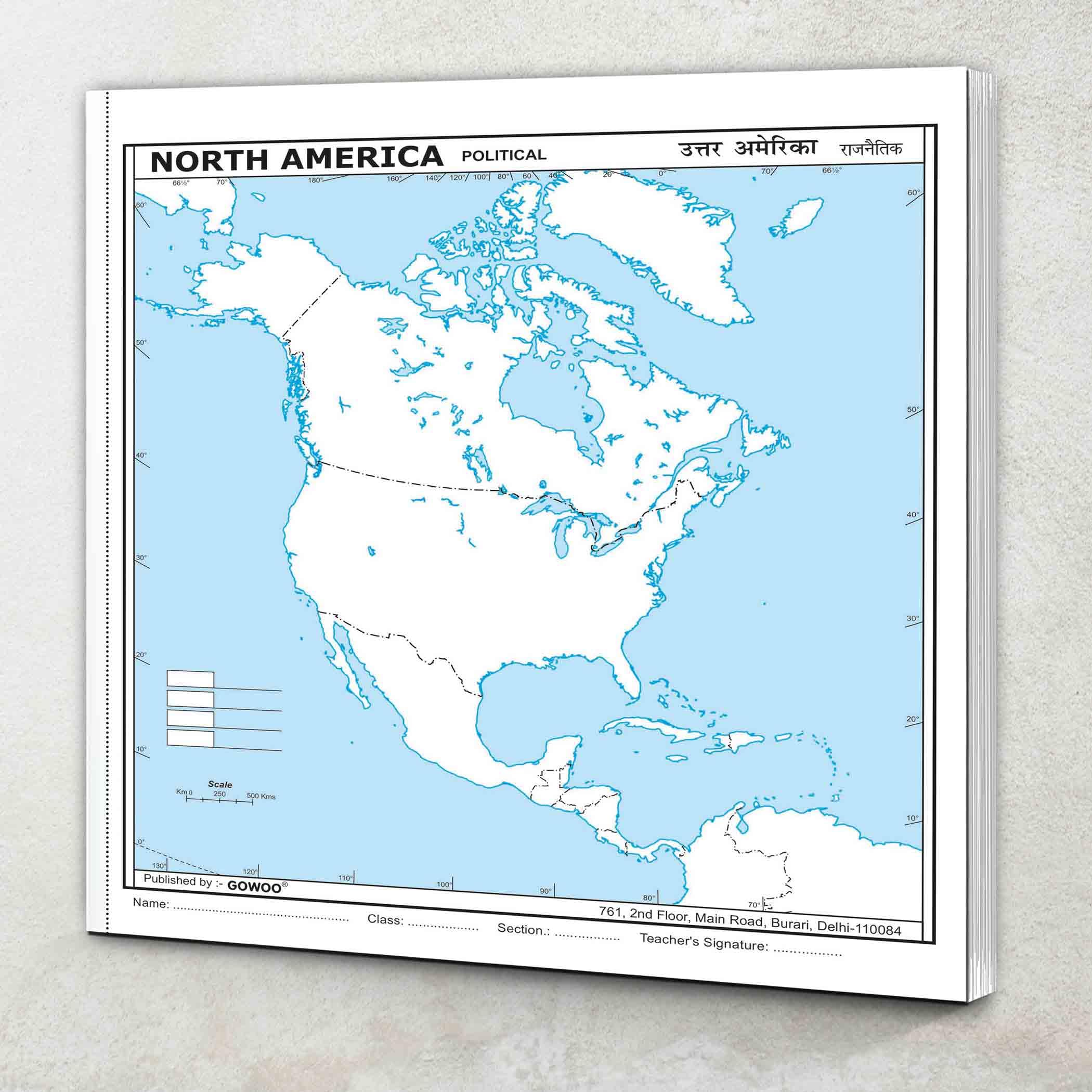
North America Map
989 G

National Geographic: The Americas Classic Wall Map - Laminated (23.75 x 36.5 inches) (National Geographic Reference Map)
6,349 G

24x36 United States, USA Classic Elite Wall Map Mural Poster (Laminated)
5,349 G

Laminated World Map & US Map Poster Set - 18" x 29" - Wall Chart Maps of the World & United States - Made in the USA (LAMINATED)
2,699 G

National Geographic Maps: United States Classic Wall Map - Poster Size - 91 x 61 cm - Front Lamination
6,304 G

USA Map Classic - Front Sheet Lamination - 86.4 (w) x 55.9 (h) cm
7,710 G

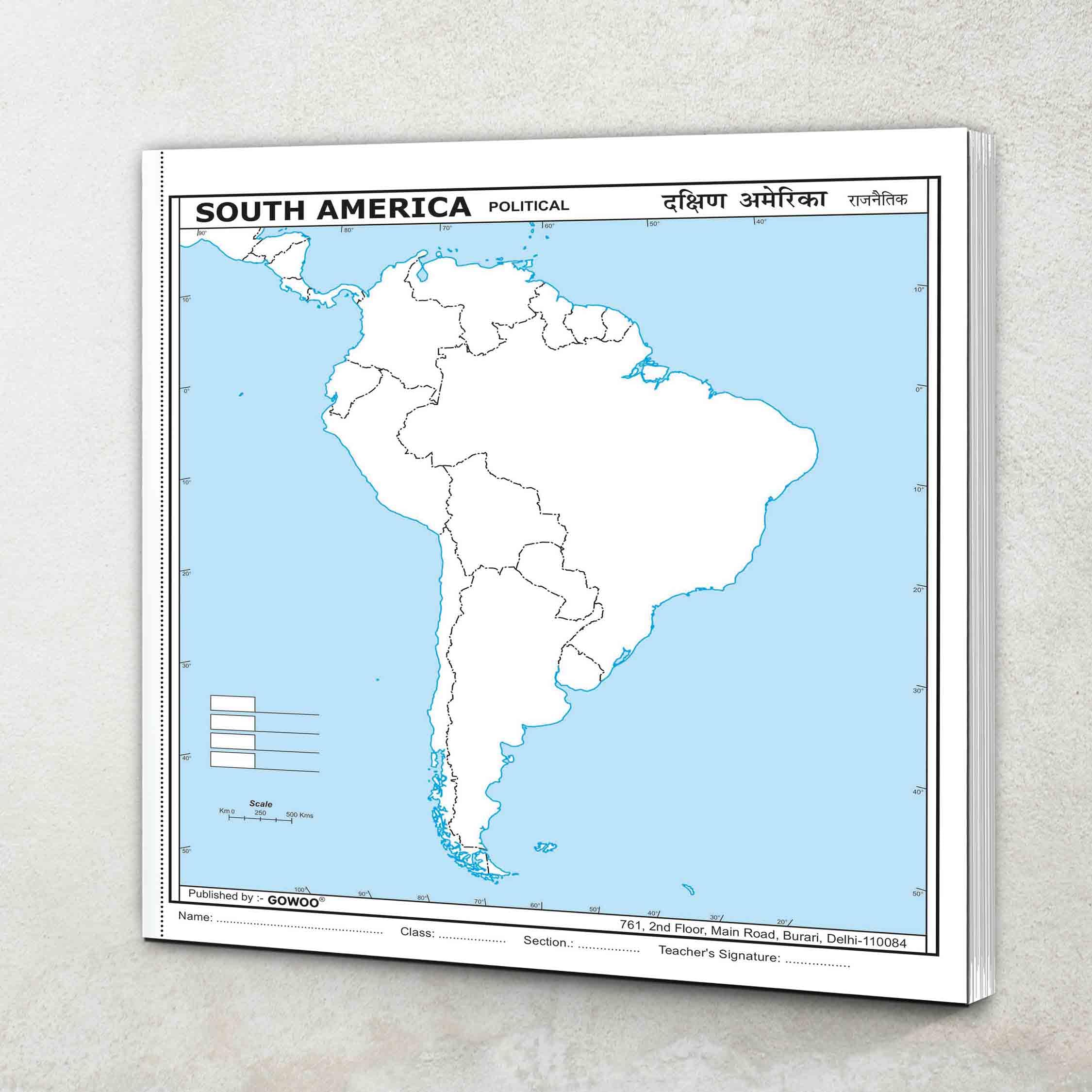
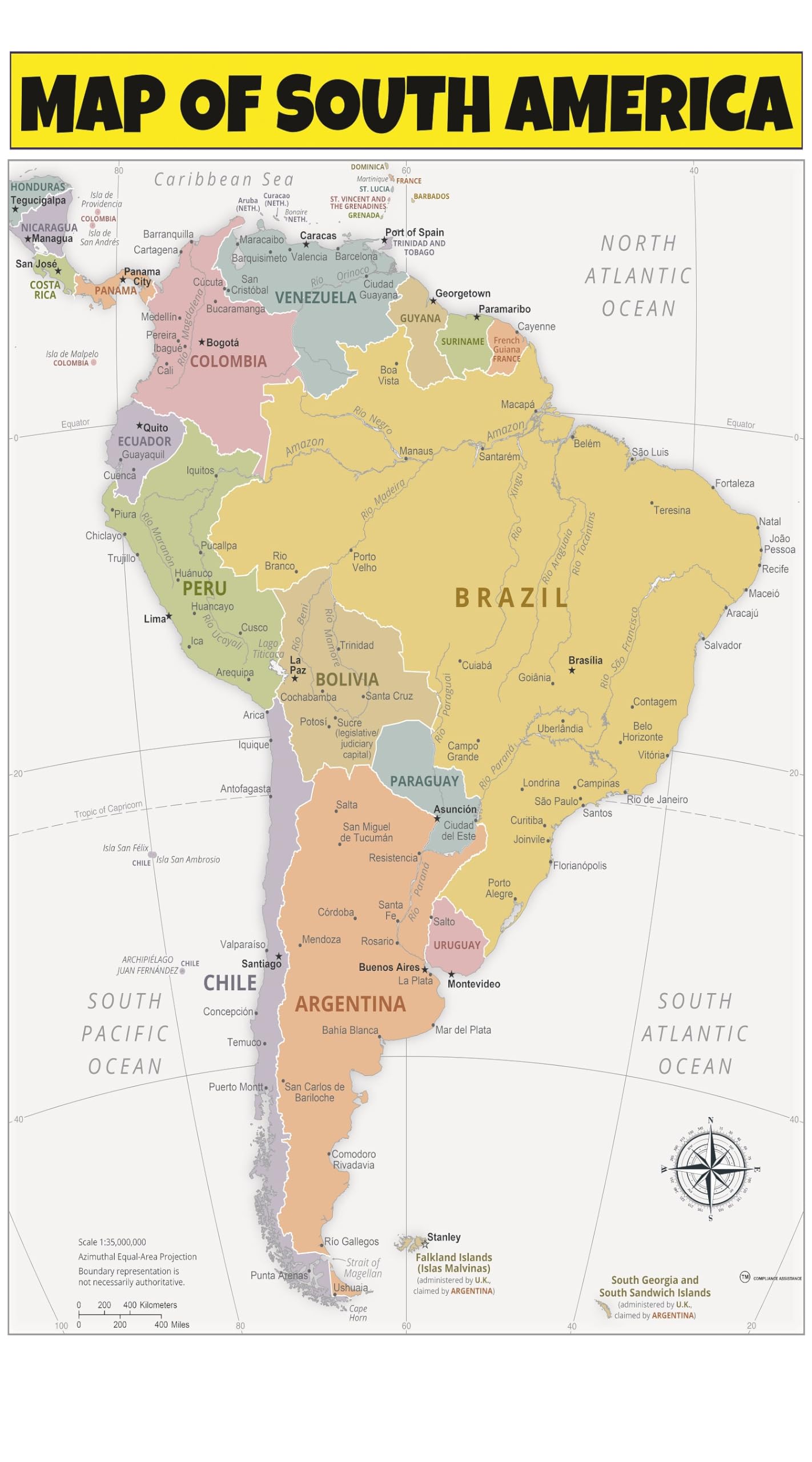
South America Political Map
1,169 G

DURABLE MAGNETIC Paper Map of UNITED STATES of AMERICA (USA) with Core Based Statistical Area (CBSA) classification, Road-Rail, Important Locations with Map-Legend, Size Size 18 X 11 inches ~ A3 SIZE LANDSCAPE
1,919 G
SMALL - 100 SOUTH AMERICA POLITICAL OUTLINE MAP FOR SCHOOL|South America political map for school
230 G

Lonely Planet Central America Planning Map
4,499 G

Close Up XXL USA Map Premium Poster - Giant America Map with all States 55" x 39" MAPS IN MINUTES
3,542 G

Lonely Planet USA Planning Map
1,789 G

United States of America Map Learning Mat
2,159 G

Map of United States of America (USA) | State, Roads & Towns | Size 2 ft. X 1 ft. | Printed on Media - 380 GSM Cotton Canvas Matte, with eyelets | Suitable for Home, Education & Small Business
916 G

SMALL - 100 NORTH AMERICA PHYSICAL OUTLINE MAP FOR SCHOOL|North America physical map for school Paperback – 18 June 2024
155 G

USA Map
1,289 G

GB eye World Maps USA 61 x 91.5cm Maxi Poster
3,089 G
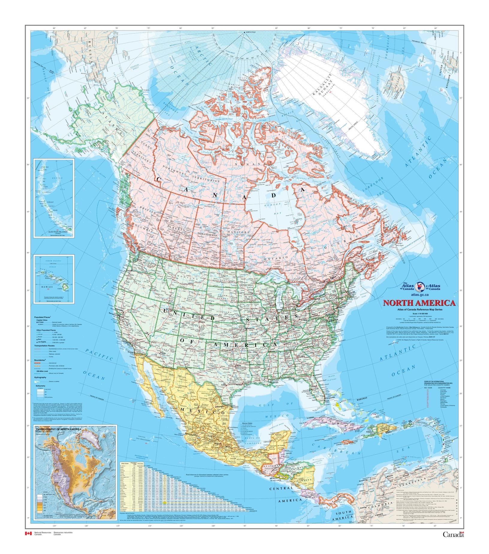
North America Wall Map - Atlas of Canada - 34" x 39" Paper
6,559 G

Map of USA 50 States with Capitals Poster - Laminated, 17 x 22 inches - Colorful Complete Map of United States for Children - North America, US Wall Map - Classroom & Homeschool
3,309 G

USA Wall Map for Kids with Illustrations- United States Poster Map for Home or Classroom, (18” x 29” Laminated)
2,679 G

Momo & Nashi United States & World Map Poster for Kids - 2 Pc - 24 x 16 Inch Waterproof USA & Map of the World Poster - for Wall Posters for Learning, Classroom, Education, Back to School Resources
4,019 G
![Giant USA Map - Mega Map of the United States of America - US Map Chart - Laminated - 46" x 60" [Blue]](https://m.media-amazon.com/images/W/MEDIAX_792452-T2/images/I/91AqF85f2WL.jpg)
Giant USA Map - Mega Map of the United States of America - US Map Chart - Laminated - 46" x 60" [Blue]
2,473 G

48x78 Huge United States, USA Classic Elite Wall Map Laminated
11,449 G

Rand McNally United States Interstate Fold Map Map – Folded Map, March 1, 2024
5,499 G

Lonely Planet South America Planning Map Map – Folded Map, November 19, 2019
2,309 G
Central America Planning Map 1 (Planning Maps)
1,549 G

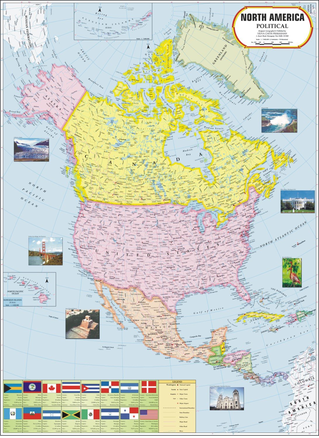
Maps International Large Political North America Wall Map - Laminated - 48 x 36
7,789 G

Scratch Off Map Of United States, USA State Scratch Sticker, Travel Map Gift Adventure Wall Poster For Kids Adults (States)
2,812 G

Teacher Created ResourcesColorful United States of America Map Chart
3,369 G

House of Doolittle Write On/Wipe Off Laminated United States Map 38 x 25 Inch (HOD721)
4,167 G
![National Geographic Road Atlas 2025: Adventure Edition [United States, Canada, Mexico] Spiral-bound – June 10, 2024](https://m.media-amazon.com/images/I/81rRihqWqgL.jpg)
National Geographic Road Atlas 2025: Adventure Edition [United States, Canada, Mexico] Spiral-bound – June 10, 2024
6,639 G

United State Map Laminated Poster -Double Side Educational Poster For Kids/Adults -18 x 24 inch Waterproof Map For Home Classroom
2,679 G

Painless Learning South America Map Placemat, 12 x 17 1/2 inches
2,459 G

Mapping America: The Incredible Story and Stunning Hand-Colored Maps and Engravings that Created the United States
5,309 G

Detailed Scratch off USA Map with Scratcher - 24x16 Easy to Frame 63 National Parks Scratch Off Travel Poster of the United States of America - Large Scratchable US Map with Landmarks and States Flags
6,009 G

2 Pack - USA Map for Kids + Blue Ocean World Map (LAMINATED, 18" x 29")
2,729 G

24x36 World and USA Classic Premier 3D Two Wall Map Set (Laminated)
6,009 G

24x36 United States, USA US Executive Wall Map Poster Mural (24x36 LAMINATED)
5,349 G

South America Wall Map GeoPolitical Edition by Swiftmaps (18x22 Laminated)
4,219 G

History of North America Map by Map (DK History Map by Map)
8,234 G

NOWMAP AquaShield Double-Sided United States, USA Map Waterproof Poster 24x36 - Folded Edition with (Pin Stickers)
4,939 G
![2 Pack - USA Map for Kids [Illustrated] + United States of America Map [Blue Ocean] (LAMINATED, 18" x 29")](https://m.media-amazon.com/images/I/A1Iz3w-oCUL.jpg)
2 Pack - USA Map for Kids [Illustrated] + United States of America Map [Blue Ocean] (LAMINATED, 18" x 29")
2,729 G

National Geographic North America Map (folded with flags and facts) (National Geographic Reference Map)
2,523 G

North American Maps for Curious Minds: 100 New Ways to See the Continent
2,970 G

KappaMapping Company United States Poster Size Wall Map 40 x 28 with Cities (1 Map)
1,559 G

TOMOZ United State Map Tapestry, US Maps Tapestry for Kids Student, Educational Tapestry Wall Hanging for Classroom Bedroom Living Room Dorm Decor 60 x 51Inch
4,879 G

Home Comforts Map of Latin America - Vivid Imagery Laminated Map Print-20 Inch by 30 Inch Laminated Map Poster With Bright Colors And Vivid Imagery
3,356 G

National Geographic Maps: United States Explorer Wall Map - 81 x 51 cm
5,531 G
South America Wall Map Laminated GeoPolitical Edition by Swiftmaps A2 (42cm x 60cm)
3,489 G

National Geographic Maps: The Americas Classic Wall Map - 92 x 61 cm
3,640 G
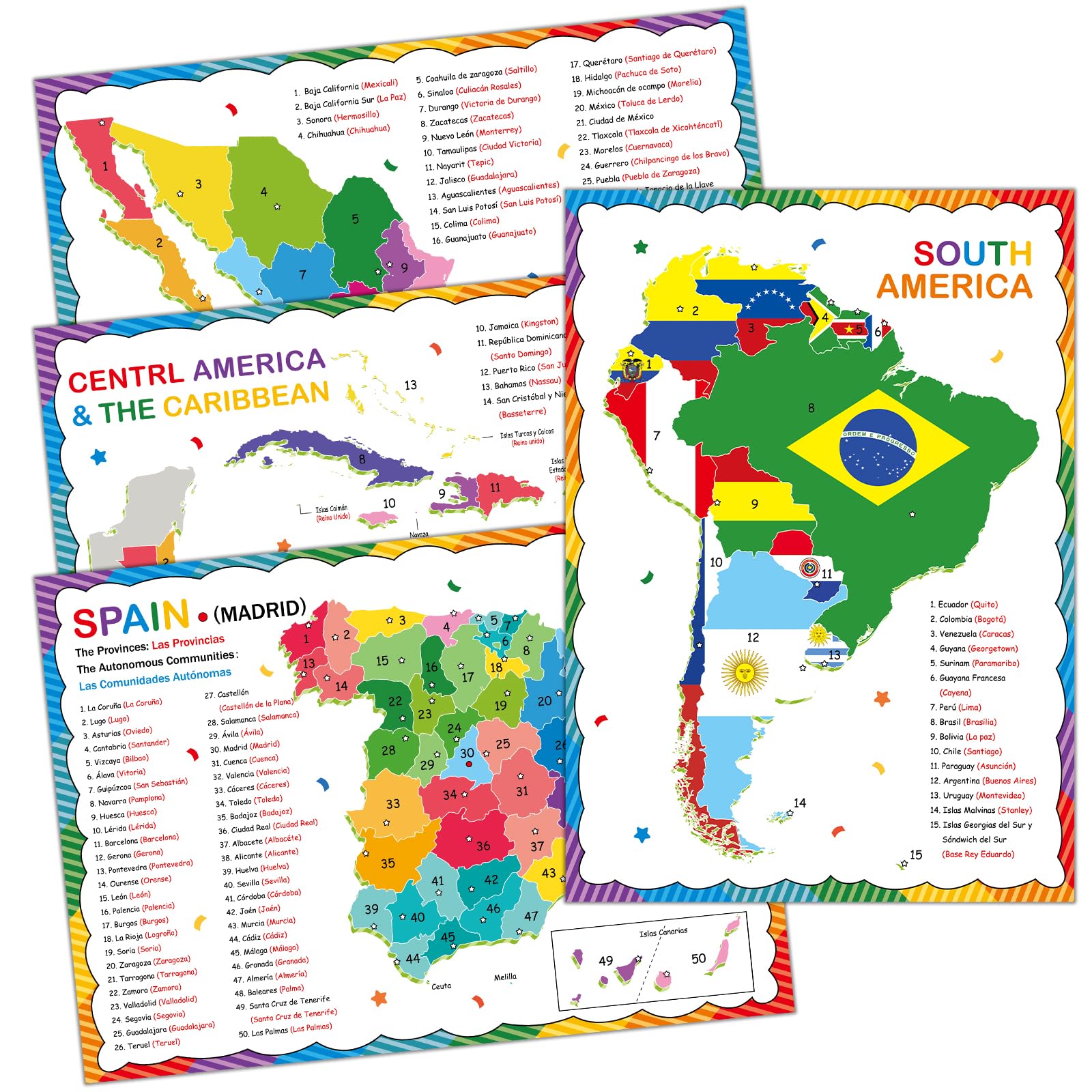
gisgfim 18 x 12 in Spanish Posters Spanish Language Country Maps Including Spain, Mexico, Central America, Caribbean, South America Spanish Classroom Decorations for Students Teachers Supplies
1,653 G

South America Wall Map Laminated GeoPolitical Edition by Swiftmaps A2 (42cm x 60cm)
2,369 G

JEWEDECO 2pcs United States Map Hanging Map of The World Large World Map Usa Map Poster Map of America United States Poster Map of The United States US Map for Europe Map Maps UV Paper
1,675 G

United States of America Political - Wall Map
23,749 G

JARLINK Scratch Off USA Map Poster, 12x17 inches United States Map with Unique Accessories Set, Personalized Travel Poster, Gift for Travelers
1,653 G
North America Wall Map Laminated GeoPolitical Edition by Swiftmaps A2 (42cm x 60cm)
4,039 G

Maps of America the Beautiful **Second Edition**
1,937 G

Pacific Coast Highway Touring Map: Plan your adventure along America’s Pacific Coast
2,176 G

Rand McNally Large Scale Road Atlas 2025 Spiral-bound – Folded Map, March 14, 2024
6,819 G

National Geographic Maps: Central America Classic Wall Map - 73 x 57 cm
3,049 G

Gifts DelightLaminated 24x28 Poster: Political Map - North America Political Wall Map
4,609 G
Map of South America 20x30 - Laminated Wall Map Poster Print Perfect for Classrooms and Homes - Vivid Imagery with Bright Colors
2,123 G

Large South America Central America Political Map on Printed Vinyl - A1 Size 59.4 x 84.1 cm
4,195 G

A History of America in 100 Maps
5,792 G
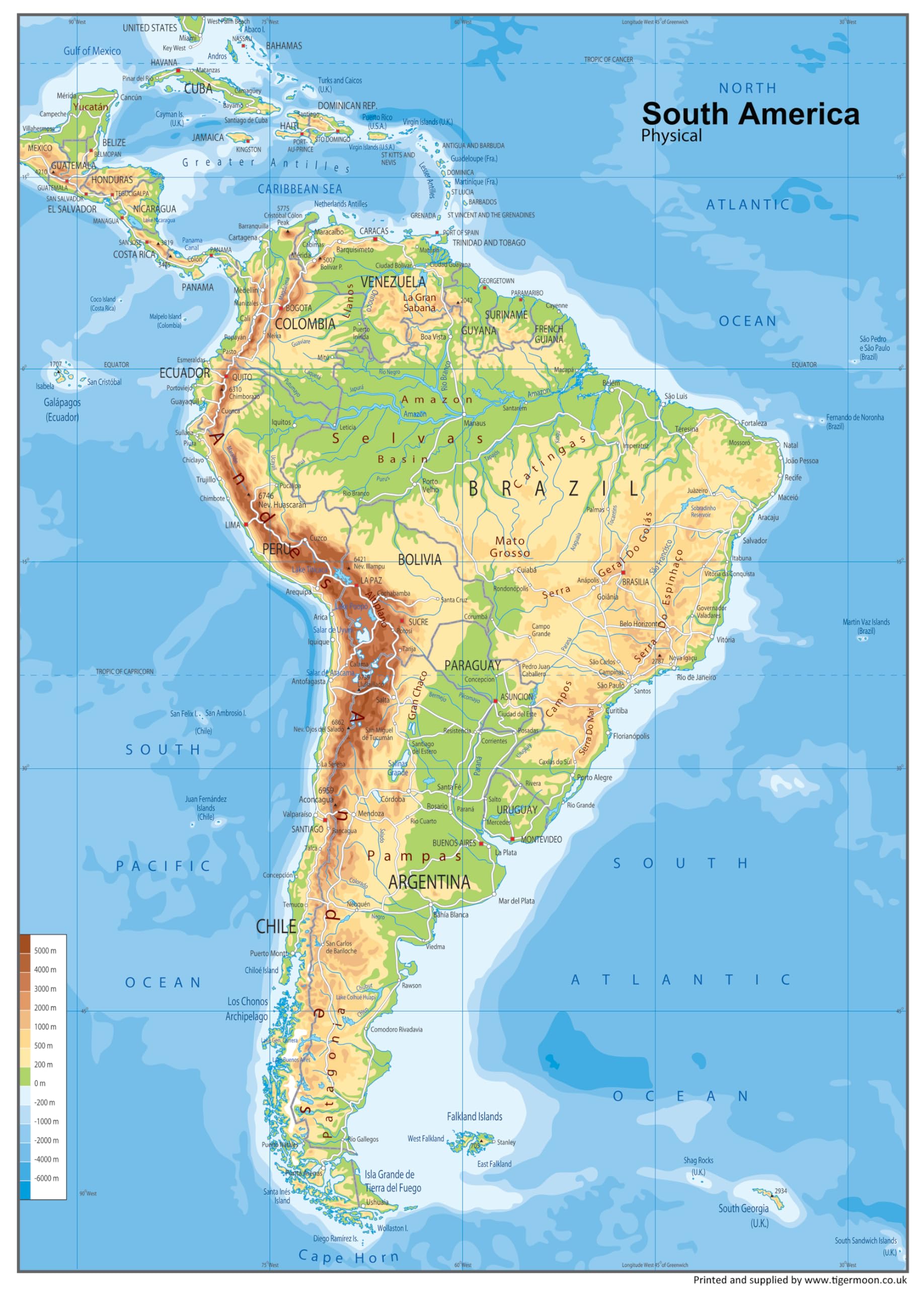
South America Physical Poster Map - 23.3 x 16.5 Inches - Paper Laminated
3,793 G

Lonely Planet South America Planning Map
1,759 G
History of North America Map by Map (DK History Map by Map)
5,093 G

Batmerry Map America Colorful Tapestry, Map of The Americas Picnic Mat Hippie Trippy Tapestry Wall Art Meditation Decor for Bedroom Living Room Dorm, 51.2 x 59.1 Inches, World Map
2,976 G

Scratch The World® Travel Map - Scratch Off World Map Poster with Gift Tube - X-Large - 84 x 59 cm - Maps International - 50 Years + of Map Making
7,399 G

The 50 United States of America Maps & Flags Coloring Book: All USA States Flags, Map with Main City Coloring Activity Book for Kids, Teens & Adult. ... Gift for Student & Travelers Boys & Girls Paperback – 5 Dec. 2020
2,759 G

Physical Map of North America - Size A1-59.4 x 84.1cm - Paper Laminated
7,059 G

Continental Series: South America - Wall Map
14,049 G

Talking Tables 1000-piece USA Jigsaw Puzzle with Poster-50 States Map-Illustrated American Landmarks-Fun at Home Family Activities, Birthday Present, Travel Gifts, Wall Art, PUZZLEUSA
3,587 G

Northeastern USA, Eastern Canada - Michelin Regional Map 583: Map (Michelin Regional Maps, 583)
2,589 G

The 50 United States of America Maps & Flags Coloring Book: USA States Map and Flag Geography Activity Book with State Main City/Capital for Adult & ... Birthday Gift / Christmas or New Year Gift
4,029 G

The 50 United States of America Coloring Book for Kids: Fifty State Maps with Capitals, Nickname, Motto, Bird, Mammal, Flower, Flags, Seals and Learn Important Facts about All 50 States Paperback – 6 Jan. 2022
2,759 G
North America Wall Map - Atlas of Canada - 34" x 39" Paper
7,349 G

Central America (Map Pack): Travel Maps International Adventure/Destination Map (National Geographic Adventure Map)
19,999 G

Insight Guides Travel Map USA & Canada South (Insight Maps) (Insight Guides Travel Maps)
1,184 G

World Map Poster for Wall – 84 x 60cm Large Wall Map of World – World Map Wall Art Atlas - Map of Europe Travel Map - Classroom or Geography Gift
2,629 G

Scratch Off Map UK | A2 Poster + Accessories Kit & Travel Poster Tube. Campervan Accessories UK Map for Day Trips. Travel Journal Wall Art. Nebula Watercolour Designed Scratch Off Poster
4,839 G

USA Scratch Map with States Flags - North America Scratch Map to Track Travel - Made in Europe - 16.54 x 11.7 In Map – Wall Map, 1 Jan. 2023
4,679 G

Political Map of South America - Size A0-84.1 x 118.9cm - Paper Laminated
7,419 G

CAXUSD 1 Set Map Hanging Map of World Poster America Maps Large America Map America Map Wall World Map World Education Map Maps for Learning Map of America for Wall Geography Map UV Paper
2,909 G

United States (USA) and Americas-Centered World Desk Map (13" x 18"), 2-Sided, Laminated by American Geographics
6,469 G

Collins Route 66 Touring Map: Plan your adventure across America
5,119 G

Close Up USA Jigsaw Puzzle 1000 pieces - The United States of America - 68 x 48 cm Premium Map 2021 - MAPS IN MINUTES
7,839 G

United States Map Print, USA Map, Watercolor United States Map, America Map, Travel Map, Wanderlust, Wall Decor, Home Decor, Map Art-1075
5,089 G

South America
3,019 G

Chile Argentina - Michelin National Map 788: Map (Maps/Country Michelin)
1,276 G

Larsen K12 United States of America Political Map, English Edition, 48 Piece Boxless Tray & Frame Jigsaw Puzzle
1,926 G

USA East Marco Polo Map: Atlantic Coast, Great Lakes and Appalachian Mountains (multi-language edition - English, German, French) (Marco Polo Maps)
4,959 G

US, California and Nevada Map: North America (National Geographic Adventure Travel Map, 3119)
4,239 G
Get the App